Cauldron rock
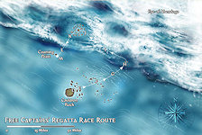
Cauldron Rock is a small island situated in the northernmost part of The Shackles close to the fringes Eye of Abendego. The small uninhabited island is just large enough to be marked on most maps of the area but its main claim to fame is as the starting location of the annual Free Captains' Regatta.
The map is keyed as follows:-
- Cauldron Rock (D).
- The Silted Shrouds (E). The Shrouds are an extensive series of shallow sandbars formed by the actions of the Eye. No up to date map exists of them as they are continuously created and then washed away by the storm.
- Raker Shoals (F). The Shoals are a series of reefs, many of which are uncharted, and a well known hazard to shipping.
- Gozreh's Flow (G). Gozreh's Flow is a strong westerly ocean current sweeping down past the Sodden Lands which creates difficulties for the competitors of the Regatta wishing to sail against it who are already probably tacking against the prevailing winds which are in the wrong direction as well.
- Iris's Splinters (H). Two jagged spires of rock rise out of the ocean with a 100 foot gap between them. Needless to say that small gap is part of the race course.
- The Edge of the Eye (I). This is the fastest but potentially the most hazardous part of the course as competitors try to ride the storm to increase their speed.
- Sharkskin Reef and Pinnacle Atoll (J). The competitors must make their way around the towering spire of Pinnacle Atoll but the fastest route involves sailing through the two concentric rings of Sharkskin Reef, one of the more difficult parts of the course.
- Lightning Storms (K). As if this area of the course wasn't difficult enough already the area is famed for its sudden lightning storms that can start with literally a flash out of the blue sky.
- The Home Stretch (L). The route out of the storm is the easiest part of the course lacking any exceptional hazard (apart from the dirty tricks of the other competitors).
- The Finish (M). The finishing line is the eastward tip of the tiny island of Coaming Point.